Large Collection of Online Historic Delaware Maps Help Researchers

Part of the 1859 Map of Kent County Delaware (French), showing Leipsic.  Source:  Library of Congress
Part of the 1859 Map of Kent County Delaware (French), showing Leipsic. Source: Library of Congress

Over the past several years there has been an enormous increase in the number of historical maps that are available online.  These digital, on-demand collections are a great aid for those seeking to understand the past, whether it is for a scholarly investigation, local history study, or genealogy project. While the


Part of the 1859 map of Kent County Delaware showing Smyrna and part of Camden.  Source:  Library of Congress
Part of the 1859 map of Kent County Delaware showing Smyrna and part of Camden. Source: Library of Congress

maps, many centuries old, have always been available in special collections repositories around the nation, access was limited as trips to widely scattered archives and access rules created obstacles for some researchers.

Here are a couple of general starting points.  One of the best is  Old Maps Online, an easy-to-use web portal to historical maps in libraries around the globe.  It allows users to search across a number of collections, via a user friendly geographical search interface.  Another strong one is the Library of Congress.  The products can be downloaded and the scans, which are of high quality, can be magnified, in most instances.  Some of repositories require you to register to get full free access.

These and other research e-resources are revolutionizing the way we conduct historical research and are invaluable for those working in the past.  Here are some specific online Delaware resources, which you should find helpful.

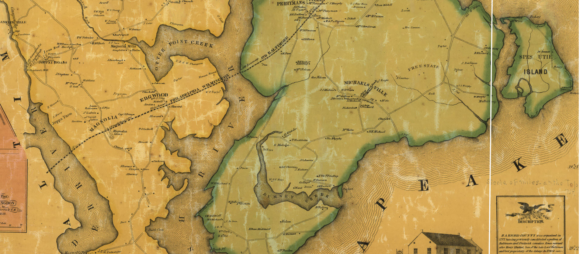
  • The Library of Congress has the J. H. French Map of Kent County Delaware (1859), It can be downloaded in a large format in order to magnify the product.  There is also the Birds-Eye View of Wilmington Delaware (1874) in addition to over 30 more products.
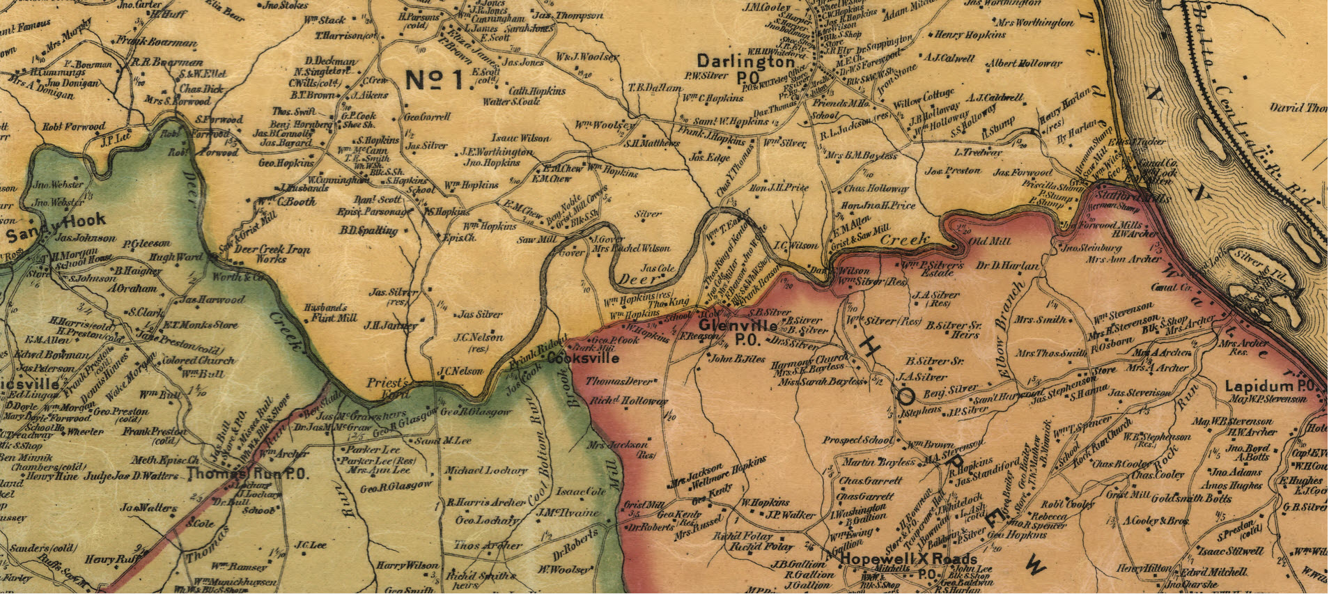
  • Old Maps Online provides a portal to the full Beer Atlas of 1868, a most valuable product for researchers.  Here is the link to Georgetown Hundred but the other plates are there too.  
  • The USGS Historical Topographic Map Collection provides acce3ss to more than 193,000 topograph maps published by the USGS since the inception of the national mapping program in 1884.  It includes the Delaware products.  Also here is another free source for these maps.  
  • Historic aerial maps of Delaware, beginning in the 1930s and running to the present, are available online through a service provided by the Delaware Geological Service’s Delaware DataMil (Data Mapping and Integration Laboratory).  This virtual service allows researchers to easily acquire detailed visual representations showing the nature of development on parcels at specific points in time.
  • On one of the local heritage weblogs we follow, the Mill Creek Hundred History Blog, we found out about some great e-cartographic content at the “New Castle Community History and Archaeology Program” site.  The publisher of that site, Jim Meeks, has made some great produts available, including a zoomable copy of the Rea & Price Map of New Castle County (1849).

You will also find a collection of historic First State Maps at the Delaware Public Archives, as well as Official Highway Maps provided by DelDOT.  The first e-product there was published in 1906 and the Official Highway Maps start in 1920.

Check these site out the next time you are working on a Delaware project, regardless of where your inquiry takes you around the State.  You will find many other maps of interest once you start searching these and other databases and with each passing year more of these resources are open sourced, greatly expanding efficiencies for those studying the past.

A plate from the Pomery & Beers Atlas of Delaware (1868) showing White Clay Creek and Newark.
A plate from the Pomery & Beers Atlas of Delaware (1868) showing White Clay Creek and Newark. Source: David Rumsey Collection via oldmapsoline.org


Newly Launched Newspaper Search Engine Focuses on Searching Historical Papers.

newspaper search engine
A search for Dover Delaware delivered this page from the Los Angeles Herald. It was published on February 22, 1899.

Efficiencies for researchers continue evolving at a rapid pace as important resources are digitized, allowing the materials to move beyond the confines of libraries, historical societies, and archives.  These open sourced, easily accessible collections on the web, greatly enhance our ability to study the past, as often untapped materials are available on-demand from a classroom, office, or home.

The current evolution is in the area of newspapers as an untold number of old, yellowing pages are digitized and rolled into databases each month so scholars, students, genealogist, and curious types may have easy access.

Now, a new newspaper search engine, Elephind.com, is helping with this by providing one specialized Google-type site for querying newspapers from many collections.  Until recently the search required knowing which place to surf over to in order to dig into the collections.  With this service, it is possible to search digital newspapers collections from around the globe in aggregate.

Elephind has just launched so this new web portal is in the early stage of its growth.

Elephind, a newspaper search engine
A search for Dover, Delaware on Elephind, a newspaper search engine

Online Historical Maps of Harford County

Over the past several years there has been an enormous increase in the number of historical maps that are available online.  These digital collections are a great aid for those of us seeking to understand the past, whether it is for a scholarly investigation, local history study, or genealogy project. While the maps, many centuries old, have been available in special collections repositories around the nation, the access was limited as trips to widely scattered archives created obstacles for most researchers.

Recently I needed to examine old drawings from Harford County, and I was able to easily access e-published renderings from a number of universities, historical societies, and libraries around the world.

There are a few helpful starting points, when accessing these primary sources.  One of the best is Old Maps Online, an easy-to-use web portal to historical maps in libraries around the globe.  It allows the user to search across a number of extensive collections, via a geographical search interface.  Another strong one is the Library of Congress.  The products can be downloaded and the scans, which are of high quality, can be magnified, in most instances.  Some of repositories require you to register to get full access.

These and other research e-resources are revolutionizing the way we conduct historical research and are invaluable for those working in the past.  Here are some sites for locating Harford County Maps online, as well as any other place you are examining.

  • Searchable on Old Maps Online, the David Rumsey Map Collection has Simon J. Martenet’s Map of Harford County, along with dozens of other digital products.
  • Old Maps Online also has Brown University Library’s C. P. Hauducoeur’s engraving of the head of the Chesapeake and Susquehanna River.  Of course, many more are found via this web portal.
  • The Library of Congress has L. W. Herrick’s Map of Harford County from 1858 and Martenet’s 1878 Map.  It also has T.M. Fowler’s 1907 birds-eye-view of Havre de Grace.
  • The Enoch Pratt Library has a subscription to the Sanborn Fire Insurance Maps. From the 1880s until about World War II, the cartographers for this company visited towns regularly to update drawings and produce sketches at a detailed scale of 1-inch to fifty feet.  With these a researcher is able to observe the changes that took place with a dwelling or a community over generations.  You need a Baltimore City Library card to access the database online.
  • Here is a link to a union catalog, an index, of all the Sanborn Maps published for Maryland.

Check these resources out the next time you are working on a project and need Harford County Maps.  Regardless of where your inquiry takes you you will find many other maps of interest as you start searching these and other databases.

A map of the head of Chesapeake Bay and Susquehanna River  by C. P. Hauducoeur; Source:  The John Carter Brown Library at Brown University, via:  Old Maps Online
A portion of the map of the head of Chesapeake Bay and Susquehanna River by C. P. Hauducoeur; Source: The John Carter Brown Library at Brown University, via: Old Maps Online
Sanborn Fire Insurance Map of Bel Air, 1897; Source Enoch Pratt Library
Part of the Sanborn Fire Insurance Map of Bel Air, 1897; Source Enoch Pratt Library

Harford County Maps, 1858.
A portion of the map of Harford Co., Maryland, 1858. Entirely from original surveys by L.W. Herrick; Source: Library of Congress

Martenet's Map of Harford County, Maryland, 1878:  Source:  Library of Congress
A part of Martenet’s Map of Harford County, Maryland, 1878: Source: Library of Congress

Thousands of Digital Delaware Picture Postcards Depict State History at Public Archives

caley 1
The Lighthouse & Keeper’s House at Taylor’s Bridge. Source: Delaware Public Archives, George Caley Postcard Collection

The Delaware Public Archives, a special collections institution that provides outstanding leadership in creating digital products to support the study of First State heritage, has just launched another valuable resource.  It is the George Luther Caley Postcard Collection, a group of almost 7,000 twentieth century images of the State and Delmarva.

George, a Smyrna resident, was a well-known genealogist, author and local historian and an avid postcard collector.  During his life-time, he assembled this valuable assortment of Delaware and Delmarva images.  When he passed away in 2005, his wife generously donated the photos to the Delaware Public Archives.  Now the professionals at this fine repository have made those images available to researchers on the World Wide Web.

Picture postcards caught on about 1906 and remained popular, sought after items throughout the 20th century.  Itinerant photographers traveled the area, from the Peninsula’s wide spots in the road to the larger towns, snapping up pictures of just about everything to supply the market.  When people vacationed, they mailed those tiny items back home.  Or when someone from Delaware corresponded with far away friends, they exchanged picture postcards of their towns.  Toward the end of the 20th century the items that had been stored away in trunks decades earlier started coming out of attics.  Those tiny pieces of cardboard became valuable, sought-after collectibles as local history enthusiasts snapped up the historical pictures of the region, many of them nearly 100-years old.

Now thanks to Mrs. Caley and the Delaware Public Archives this valuable  collection has been carefully preserved and it is available to a wide audience.

Click here to visit the postcard collection

The Caley Postcard Collection Homepage at the Delaware Public Archives website